Synopsis
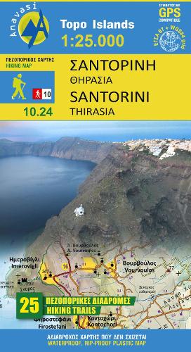
As you enter the caldera of Santorini by ferry sheer cliffs rise up dramatically, exposing richly coloured rock strata, crowned by the colored houses of the cliff-top settlements. Equally magnificent is the sunset from the heights of the caldera towards the sea and the remnants of prehistoric rounded island Strogyli, Thirasia, the New and Old Kameni. However, there is more than the visual excitement to discover and if you don?t take the time to walk the island you will have learnt little of Santorini.
The new Anavasi map will take hiking in every corner, beach and hill top of Santorini and Thirassia to discover landscapes with visible signs of the traditional rural culture, with orchards stonewalls, threshing floors, huts, chapels, inland villages with a well preserved medieval core (called Castelo), routes with wonderful vistas, lost beaches quiet even in the heart of summer.
The new map is double in size and scale than the previous version, that means more information and detail. On the reverse side of the map, there is a brief description of the 25 proposed hiking routes and a short guide of the two islands, Santorini and Thirassia.
Publisher information
- Publisher: Anavasi
- ISBN: 9789609412728
- Number of pages: 1
- Dimensions: 230 x 130 mm
- Languages: English
Customer Reviews
You may also like...