Philip's Reference Map: Britain and Ireland: Political
Synopsis
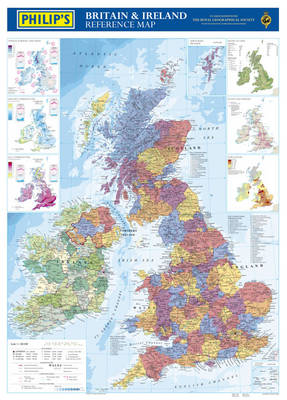
Philip's Britain and Ireland Reference Map is created from the latest digital cartography. The wall chart features a brightly coloured large-scale map of the British Isles, in political coloration and with clear lettering and symbols for easy reference. Counties and administrative areas are picked out in distinctive colours to aid identification, with town and city names clearly shown. Also included on the chart alongside the large political map is a physical map of the British Isles, together with smaller thematic maps covering the important topics of Population, Rainfall, Wealth, and Transport. This wall chart is supplied rolled flat into a clear plastic tube and laminated on one side only. It is ideal for mounting on a bedroom wall or in the workplace - the clarity of the maps ensures that it is highly accessible for business purposes and general study.
Publisher information
- Publisher: Octopus Publishing Group
- ISBN: 9780540089161
- Dimensions: 950 x 48 x 48 mm
- Weight: 164g