Synopsis
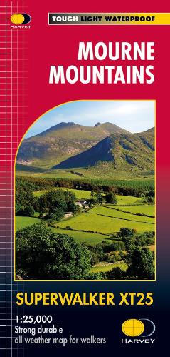
The Mournes, a granite mountain range in County Down, includes the highest mountains in Northern Ireland. The highest is Slieve Donard at 850 metres. Detailed map for hillwalkers of the Mountains of Mourne at 1:25,000 scale. The Mournes is an Area of Outstanding Natural Beauty and has been proposed as the first national park in Northern Ireland. The area is partly owned by the National Trust and sees a large number of visitors every year. The Mourne Wall is among the more famous features in the Mournes. It is a 35km (22mls) drystone wall that crosses fifteen summits, constructed in 1904 and completed in 1922 to define the boundaries of land purchased by the Belfast Water Commissioners in the late 1800s. Includes The Mourne Way Long Distance Footpath. Tough, light, durable and 100% waterproof Genuine, original, HARVEY mapping Opens directly to either side of the sheet Easy to re-fold
Publisher information
- Publisher: Harvey Map Services Ltd
- ISBN: 9781851376124
- Number of pages: 1
- Dimensions: 243 x 116 mm
- Weight: 32g
- Languages: English
Customer Reviews
You may also like...