Imray Chart Pack 2100: Thames Estuary to the Solent
Map Published on: 01/07/2012
Price: £37.50
Synopsis
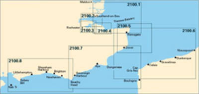
A pack of 8 charts for the Kent and Sussex Coasts. The pack includes: 2100.1 Thames Estuary South 1:120,000 2100.2 River Thames Sea Reach 1:50,000 2100.3 River Medway 1:40,000 2100.4 The Swale 1:40,000 2100.5 North Foreland to Dover 1:120,000 2100.6 Dover Strait 1:200,000 2100.7 Dover to Beachy Head and Boulogne 1:175,000 2100.8 Beachy Head to Nab Tower 1:160,000 New editions can be ordered as single replacement sheets
Publisher information
- Publisher: Imray,Laurie,Norie & Wilson Ltd
- ISBN: 9781846234927
- Dimensions: 640 x 840 mm