

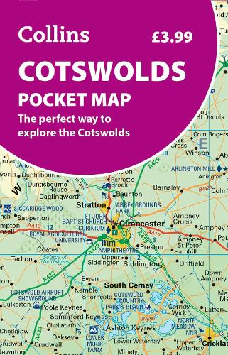
Cotswolds Pocket Map: The Perfect Way to Explore the Cotswolds
Map Published on: 04/06/2026
Price: £3.99
Synopsis
Disover new places with handy pocket maps from Collins.
The Cotswolds, in south-central England, is a picturesque region known for rolling hills, charming stone villages, and historic market towns. With its honey-colored cottages, scenic walking trails, and cozy pubs, it offers timeless rural beauty, heritage sites, and a peaceful escape in the heart of the English countryside.
This handy little full colour map of the Cotswolds has detailed mapping and tourist information, making it ideal for any road trip.
Coverage extends to Worchester in the north, Oxford in the east, Trowbridge in the south, and Cinderford in the west.
Main features of this map include:
- Clear mapping
- Main tourist attractions located and described
- Ideal for touring with sights, places to stay, cafe/restaurant, golf courses, things to do all on the map
- Essential travel information
- Index to places of interest and place names
Essential for those planning a trip around the Cotswolds.
Publisher information
- Publisher: HarperCollins Publishers
- ISBN: 9780008780395
- Number of pages: 1
- Dimensions: 140 x 90 x 5 mm
- Weight: 40g
- Languages: English
Customer Reviews
You may also like...

Cairngorms and Lochnagar
Price: £18.95

Skye Trail
Price: £16.50
South Downs Way
Price: £16.50

Ben Nevis and Glen Coe
Price: £18.95
Cumbria Way
Price: £16.50

The Penguin Map of the World
Price: £8.99

Pentland Hills XT25
Price: £15.95
Xploreit Map of County Cork, Ireland
Price: £18.99

Southern Highlands
Price: £17.50
Strangford Lough
Price: £10.99


West Highland Way
Price: £16.50
Ochil Hills
Price: £15.95

Korfu, Automap 1:50.000
Price: £12.90