Synopsis
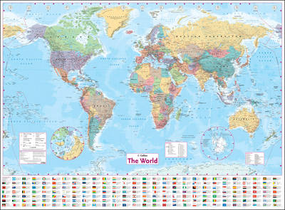
FLAT PAPER EDITION A new, updated edition of an ideal reference map covering the whole world, showing the political units on each continent. Includes national flags and key statistics for every country. Scale 1:22 000 000 MAIN FEATURES Fully updated political map showing individual countries and includes roads, railways, cities and towns, and physical features. Inset maps of the polar regions, national flags and key statistics for each country. AREA OF COVERAGE All of the world, centred on the Greenwich Meridian. WHO THE PRODUCT IS AIMED AT Home and business user as well as educational use. OTHER VERSIONS AVAILABLE Flat map, laminated in tube
Publisher information
- Publisher: HarperCollins Publishers
- ISBN: 9780007326877
- Dimensions: 1015 x 1380 mm
- Weight: 20g